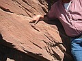
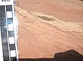
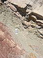
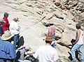
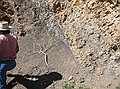
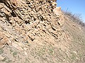
Stop #5 - Upper Lykins formation: Truncated crossbeds with ripples resulting from vortex motion (which Emmett is pointing out in this image). The motion takes sand that has avalanched off and pushes the grains back up.
|
Upper Lykins formation: ripples on ancient surface.
|
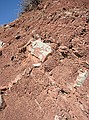
Upper Lykins formation: Here we see lose shales and muds which are present between the harder sandstone layers. This is the result of long periods of alternating wet and dry.
|
Upper Lykins formation: Alternating deposition of muddy shales (below) and sand (above). Sandstone is much more resistant to erosion than shales. That is why the sandstone ledge sticks out further than the underlying shales.
|
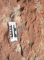
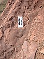
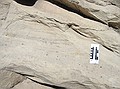
Upper Lykins formation: These finer cross laminations within the larger cross bedding of the dune are caused by swirling winds at the base (margin) of the dune. They are often perpendicular to the main cross beds. (Scale in centimeters)
|
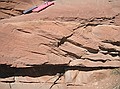
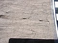
Upper Lykins formation: Cross bedding in the sand dune with truncated top margin.
|
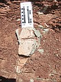
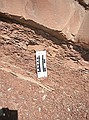
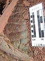
Upper Lykins formation: Proof that this area experienced periods of wetness and severe drying. Here a mudcrack occurred in the ancient surface. The gray material filled in the mudcrack and later hardened. The tapered shape is common in mudcracks because evaporation is more extreme near the surface which pulls the crack open wider as surrounding mud dries and shrinks. The lower you go, the less evaporation occurs. The hillside was covered with these mudcracks.
|
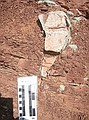
Upper Lykins formation: Another view of the previous mudcrack.
|
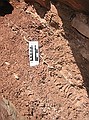
Upper Lykins formation: More mudcracks filled with gray rock
|
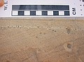
Upper Lykins formation: Sinuous crested sand ripples on ancient surface.
|
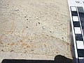
Upper Lykins formation: Straight (or oscillatory) crested sand ripples on ancient surface. (caused by back and forth motion of the water)
|
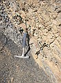
Contact point between Lykins formation (reds) and Canyon Spring sandstone (whites). Emmett's hand is on the Canyon Spring sandstone. The greenish layer in between is where iron has leached out of the uppermost Lykins formation.
|
Closer view of contact point between Lykins formation (reds) and Canyon Spring sandstone (whites). The greenish layer in between is where iron has leached out of the uppermost Lykins formation. A disconformity exists here because approx. 70 million years of deposition is missing here between the early Triassic Lykins formation and the mid-to-late Juarssic Canyon Spring sandstone.
|
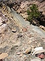
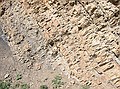
Canyon Spring sandstone: Ancient dunes with truncated crossbeds, wind blown lags (small, evenly dispersed pebbles). Canyon Spring sandstone averages only 30 ft in thickness.
|
Canyon Spring sandstone: "Lag sands" (tiny pebbles) which are transported, broken apart and evenly dispersed in high winds of dune environment.
|

Canyon Spring sandstone: "Lag sands" (tiny pebbles) which are transported, broken apart and evenly dispersed in high winds of dune environment.
|

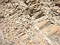
A very revealing image. The horizontal cross beds coming in from the left of the picture are truncated by the diagonal cross bed coming from top left and proceeding to bottom right. The sand dunes shifted dramatically, thus truncating the previous layers. Right at the contact point, you can see "lag sand" (tiny pebbles) which are transported and broken apart in high winds in the dune environment. These are precisely the winds that cause the shift in the dunes.
|
(Closeup of previous image.) Canyon Spring sandstone: "Lag sands".
|
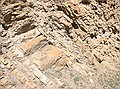
(Broader view of previous 2 images.) Canyon Spring sandstone: truncated crossbeds of sand dune.
|

Morrison formation: cross-laminations in channel complex (clays & muds).
|
Morrison formation: cross-laminations in channel complex (clays & muds). Overall, the Morrison formation consists of clays, siltstones, and carbonates (e.g. gypsum) which accumulated in a warm, moist lowland environment. Sluggish rivers were responsible for the deposit of mud and silt, which hardened into shale and siltstone respectively. Gypsum forms from the evaporation of a warm shallow sea.
|

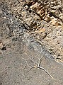
Ladybug traversing modern day debris flow. Surely she is contemplating her geologic environment?
|
Dakota Formation - Lower section is river deposits, then comes coastal beaches, then marine shales. The Dakota has two sequences of the ocean moving in and back out again... the ocean came in and out twice, then came in to stay. This image shows gray marine shales surrounded by two intervals of sandy, near shore sandstone deposits.
|
Dakota Formation - alternating gray marine shales and near shore sandstone deposits.
|

Dakota Formation - panoramic image of 5 separate pictures that were 'stitched' together to get a better view of the Dakota formaion.
|
Dakota Formation - Image 1 of 5 for panoramic image. Some layers of sandstone may have been the result of large storms which washed sand out to sea, only to be later covered up again by marine muds/shales.
|
Dakota Formation - Image 2 of 5 for panoramic image. This portion of the Dakota is the beginning of the Western Interior Seaway that eventually covered an east/west area from Utah to Ohio (?), and north/south from Canada to Texas.
|
Dakota Formation - Image 3 of 5 for panoramic image.
|
Dakota Formation - Image 4 of 5 for panoramic image.
|
Dakota Formation - Image 5 of 5 for panoramic image.
|
Dakota Formation - Contact point in Dakota formation where marine shales (gray) meet beach sandstones (tan).
|