Click on any photo to see a larger version
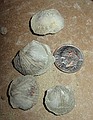
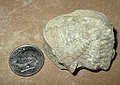
 Brachiopods I found at White Mound. Appear to be the following species: - Oxoplecia, - Sphaerirhynchia lindenensis (Dunbar) - Glyptorthis costellata (Cooper) - Hesperorthis sulcata (Cooper) Haragan Fm., Hunton Group near Sulpher, Oklahoma in Arbuckle Mtns. Pat and Merylyn Howe's "White Mound" property |
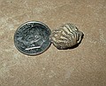
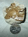
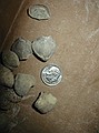 Unidentified brachiopods I found at White Mound. near Sulpher, Oklahoma in Arbuckle Mtns. Pat and Merylyn Howe's "White Mound" property |
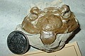
 Horn corals and crinoid stems I found at White Mound. near Sulpher, Oklahoma in Arbuckle Mtns. Haragan Fm., Hunton Group. Pat and Merylyn Howe's "White Mound" property |
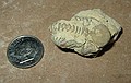
 Brachiopods (Glyptorthis) I found at White Mound. near Sulpher, Oklahoma in Arbuckle Mtns. Pat and Merylyn Howe's "White Mound" property |
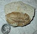
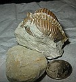
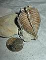
 South-end of large, unprepped trilobite found at White Mound Huntonia oklahomae (Richardson) Haragan Fm., Hunton Group. Lower Devonian near Sulpher, Oklahoma in Arbuckle Mtns. Pat and Merylyn Howe's "White Mound" property |
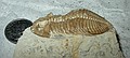
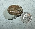
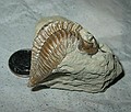
 Unprepped trilobite I found at White Mound Kainops invius (Campbell) Haragan Fm., Hunton Group. Lower Devonian near Sulpher, Oklahoma in Arbuckle Mtns. Pat and Merylyn Howe's "White Mound" property |
 Unprepped trilobite I found at White Mound Kainops invius (Campbell) Haragan Fm., Hunton Group. Lower Devonian near Sulpher, Oklahoma in Arbuckle Mtns. Pat and Merylyn Howe's "White Mound" property |
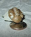
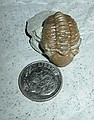
 Trilobite head. Huntonia oklahomae (Richardson) Cravat Member-Bois d'Arc Formation Lower Devonian-Helderbergian near Clarita, Coal County, Oklahoma (Geological Enterprises, Inc. property) purchased for $2. |
 Trilobite head. Huntonia oklahomae (Richardson) Cravat Member-Bois d'Arc Formation Lower Devonian-Helderbergian near Clarita, Coal County, Oklahoma (Geological Enterprises, Inc. property) purchased for $2. |
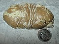
 Card says: Kainops invius (Campbell) But looks like: Huntonia oklahomae (Richardson) Bois d'Arc Formation, Cravat Member Lower Devonian - Helderbergian Clarita, Coal County, Oklahoma; Quarry owned by Geological Enterprises, Inc Purchased for $5. |
 Card says: Kainops invius (Campbell) But looks like: Huntonia oklahomae (Richardson) Bois d'Arc Formation, Cravat Member Lower Devonian - Helderbergian Clarita, Coal County, Oklahoma; Quarry owned by Geological Enterprises, Inc Purchased for $5. |
 Kainops invius (Campbell) Bois d'Arc Formation, Cravat Member Lower Devonian - Helderbergian Clarita, Coal County, Oklahoma; Quarry owned by Geological Enterprises, Inc Purchased for $5. |
 Kainops invius (Campbell) Bois d'Arc Formation, Cravat Member Lower Devonian - Helderbergian Clarita, Coal County, Oklahoma; Quarry owned by Geological Enterprises, Inc Purchased for $5. |
 Kainops invius (Campbell) Bois d'Arc Formation, Cravat Member Lower Devonian - Helderbergian Clarita, Coal County, Oklahoma; Quarry owned by Geological Enterprises, Inc Purchased for $5. |
 Homotelus bromidensis (Esker) Bromide Formation, Pooleville Member Ordovician-Blackriverian Criner Hills, Carter County, S/W of Ardmore, OK Geological Enterprises, Inc. property Purchased for $10. |
 Huntonia oklahomae (Richardson) Bois d'Arc Formation, Cravat Member Lower Devonian - Helderbergian Clarita, Coal County, Oklahoma; Quarry owned by Geological Enterprises, Inc. |
 Huntonia oklahomae (Richardson) Bois d'Arc Formation, Cravat Member Lower Devonian - Helderbergian Clarita, Coal County, Oklahoma; Quarry owned by Geological Enterprises, Inc. |
 Huntonia oklahomae (Richardson) Bois d'Arc Formation, Cravat Member Lower Devonian - Helderbergian Clarita, Coal County, Oklahoma; Quarry owned by Geological Enterprises, Inc. |
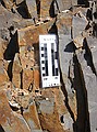
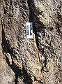
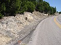
 Crinoid stems Stop #3: Roadcut underneath I-35, near Falls Creek Assembly & on Hwy 77-D, South. I-35 passes over state highway 77-D just south of the Turner Falls exit. The actual cut is on 77-D and runs about 1/4 mile east and west of I-35. Roadcut on the west side of I-35 is Devonian/Silurian limestone. It is slightly yellowish in color and contains trilobites, crinoids, brachiopods, etc. GPS waypoint "OK2". |
 Unprepped, unidentified brachiopod & chrinoid stem Stop #3, GPS waypoint "OK2". |
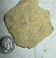 Unprepped, unidentified chrinoid stems Stop #3, GPS waypoint "OK2". |
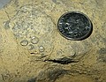
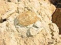
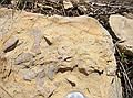
 Unprepped, unidentified inverts. Notice texture of middle & middle right. Stop #3, GPS waypoint "OK2". |
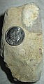
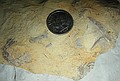
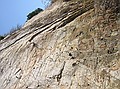
 Unprepped, unidentified inverts from Ordovician Oil Creek Fm. - a sandy limestone said to contain trilobites, Roadcut on I-35, mile marker 46.1, north of Ardmore, OK, west face of roadcut on northbound route, GPS waypoint "OK1". (northbound I-35 was closed for construction) |
 Oklahoma, Stop #1: I-35 (west face of roadcut on closed Northbound lanes). Mile marker 46.1, north of Ardmore, OK, GPS waypoint "OK1". Ordovician Oil Creek Fm. - a sandy limestone - that contains trilobites. |
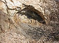
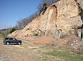
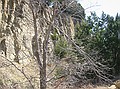
 The Woodford Shale (a Mississippian shale that is the source of most of Oklahoma's oil). |
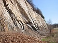 Woodford Shale (Mississippian). |
 Woodford Shale (Mississippian). |
 Woodford Shale (Mississippian). |
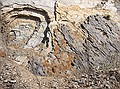 Woodford Shale (Mississippian), collapsing into arches, while the heavier/denser black material remains at center and right. |
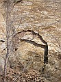 Woodford Shale (Mississippian). |
 Woodford Shale (Mississippian). |
 Woodford Shale (Mississippian). |
 Woodford Shale (Mississippian). |
 Woodford Shale (Mississippian). |
 Woodford Shale (Mississippian) - a recent collapse. |
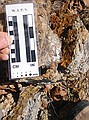
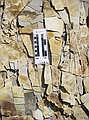
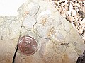
 West side of I-35 on 77-D roadcut (stop #4) Devonian/Silurian limestone. Calcereous as shown in this image which violently fizzes with a few drops of hydrochloric acid (HCL). It is slightly yellowish in color and contains trilobites, crinoids, brachiopods, etc. |
 Calcereous Devonian/Silurian limestone fizzes violently with HCL. Found brachiopods and crinoid stems here. |
 Stop #4, Arbuckle Mtns, Elev: 875 ft, Hwy 77-D roadcut (where it passes under I-35). Take Davis (Hwy 7) exit, go west for 1/4 mile, then onto 77-D road. Roadcut underneath I-35, near Falls Creek Assembly & on Hwy 77-D, South. I-35 passes over state highway 77-D just south of the Turner Falls exit. The actual cut is on 77-D and runs about 1/4 mile east and west of I-35. Roadcut on the west side of I-35 is Devonian/Silurian limestone. It is slightly yellowish in color and contains trilobites, crinoids, brachiopods, etc. GPS waypoint "OK2". |
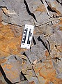
 Stop #5 - further south on 77-D near the Falls Creek Assembly, just past peak of hill. More brachiopods and crinoid stems here, plus some other unknowns. |
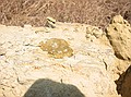
 Looks like stromatilite surface, but has sponges/byrozoans (?) |
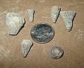
 Unknowns. Specimen at left has interesting texture. |